How it Works
Incorporating a site analysis plan into the development review process can result in designs that offer superior protection of important natural, historical, and cultural features of a site and integration into the larger community. The site analysis plan identifies resources that may be impacted by a development proposal, in an effort to best mitigate development impacts and retain the vitality of these resources.
Benefits
Pre-Engineering Planning
When the analysis is undertaken prior to the development of fully engineered plans, it can identify how resources can be protected or incorporated into the proposed development. Working collaboratively with an applicant at this stage is critical as it becomes more difficult to work through preservation issues once the plan has been engineered.
Natural Resource Preservation
The analysis identifies unique, endangered, and sensitive natural resources to facilitate their preservation to the highest degree. These natural resources include, but are not limited to, flood prone areas, riparian zones, steep slopes, wetlands, wooded areas, and prime agricultural soils.
Historic Preservation
The analysis identifies critical historical resources and landscapes to facilitate their preservation and/or potential reuse.
Energy Conservation
Through the identification of specific areas for preservation and development, more efficient siting of lots, roads, and infrastructure can be achieved.
This site analysis plan in New Garden Township inlcudes multiple features on one map.
Get Started
A site analysis plan is typically required through the municipal subdivision and land development ordinance as authorized under Article V of the Pennsylvania Municipalities Planning Code. Linking site resources such as vegetation, slope, historic resources and drainage patterns to proposed development layouts is a primary reason for incorporating the site analysis into the ordinance's plan information requirements.
The following information is typically required on a site analysis plan, including the area adjacent to the proposed development, and generally complements other required plan information. Please note that not all resources listed will be applicable in every case:
Contour lines depicting terrain shown at specific intervals.
Steep slopes in different ranges (i.e. less than 15 percent, 15-25 percent, and greater than 25 percent).
Flood hazard districts.
Watercourses and water bodies (perennial and seasonal).
Drainage basins and sub-basins.
Wetlands, wetland margins, and areas with high groundwater.
Riparian buffers.
Soil types and their boundaries, highlighting hydric, alluvial, and prime agricultural soils.
Geological characteristics, including rock formation type(s) and locations of fault zones (particularly in areas with carbonate geology).
Woodlands (while some municipalities require only the identification of woodland boundaries, others require a more detailed inventory of existing vegetation, such as tree masses, tree lines, and hedgerows, individual trees over six inches in diameter, wetland vegetation, meadows, and pastures).
Viewsheds and ridgelines.
PNDI sites (Pennsylvania Natural Diversity Inventory).
Man-made features, including historically significant sites or structures, buildings, driveways, sidewalks, streets, alleys, trails, water and sewer facilities, hazardous sites, dumps, underground tanks, active and abandoned wells, quarries, and landfills.
Considerations
Timing
The research necessary in development of a site analysis plan requires additional preparation by the developer and review time by municipal staff.
Waivers
If the information required as part of the site analysis plan becomes too onerous to address by the applicant, it may result in waiver requests for some plan requirements.
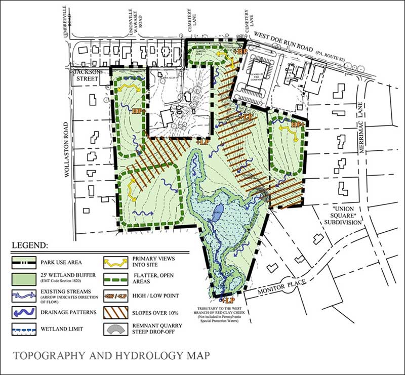
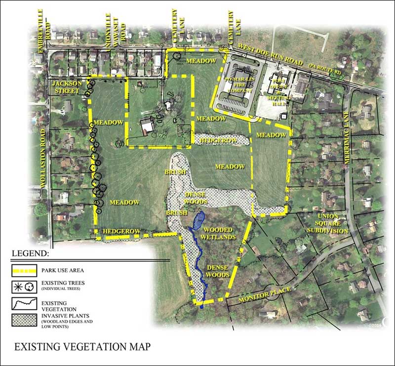
Site analyses, such as this plan in Unionville, may include inventories of features on separate maps: biotic resources; topography; hydrology; soils; meteorology; vegetation; and more.
Examples
Contemporary subdivision and land development ordinances require the applicant to map a comprehensive inventory of natural resources and other features, and provide the site information needed to enforce other municipal land use regulations. Municipalities with site analysis standards include:

East Coventry Township Natural and Historic Resources Protection standards, found in Section 429 of its Subdivision and Land Development Ordinance.

East Pikeland Township Natural and Historic Features Protection standards, found in Section 425 of its Subdivision and Land Development Ordinance.

North Coventry Township Open Space/Protected Lands Review Standards, found in Section 320 of its Subdivision and Land Development Ordinance.

Pennsbury Township Subdivision and Land Development Ordinance, found in Sections 404-407.


